Save

User PcFreak963 uploaded this Hot Map - Missing Maps OpenStreetMap Humanitarian Aid Geographic Data And Information PNG PNG image on August 25, 2018, 12:54 pm. The resolution of this file is 1280x373px and its file size is: 8.53 KB. This PNG image is filed under the tags:
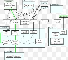
Hot Map - Missing Maps OpenStreetMap Humanitarian Aid Geographic Data And Information PNG
Below are more related PNG images...