browse
logos
calendar
log in
sign up
Browse PNG's
Famous PNG Logos
Events Calendar
Popular PNG's
Newest PNG's
PNG's by Color
AI Background Remover
AI Image Editor
Help / FAQ
User Anodev uploaded the image
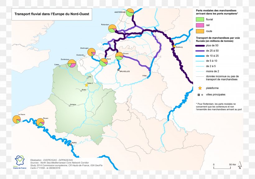
Inland Navigation Map Port Of Calais Transport PNG
. The Inland Navigation Map Port Of Calais Transport PNG has a transparent background, is 1.16 MB and has a resolution of 4379 x 3067 pixels.
Inland Navigation
Area
Calais
Diagram
Ecoregion
Europe
Map
Marchandise
Port
Rail Transport
Rail Transport Operations
Seamanship
Transport
Water Resources
World
Inland Navigation Map Port Of Calais Transport PNG
Download PNG
(1.16 MB)
4379 x 3067
1.16 MB
Anodev
Editorial Use
Edit PNG
AI Background Remover
Related PNG Images
Navigation
Map
Location
Travel
Location Marker
Map Pin
Google Maps Logo
Map Marker
Direction
Location Pin
Gps
Map Icon
Digital Navigation
Navigation Tool
Location Icon
Route Planning
Map Navigation
Travel Planning
Location Symbol
Location Logo
Location Services
Marker
Digital Maps
Google Maps
Navigation Symbol