Save
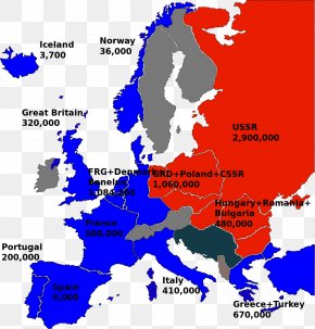
User DrMario uploaded this Map - GPS Navigation Systems Europe Second World War Map Satellite Navigation PNG PNG image on February 15, 2018, 7:37 am. The resolution of this file is 1000x1000px and its file size is: 757.76 KB. This PNG image is filed under the tags:
Map - GPS Navigation Systems Europe Second World War Map Satellite Navigation PNG
Below are more related PNG images...